In a previous article, Donal Daly introduced the concept of…
Blanket Bogs, Hydrology & Ecosystem Services to Water
Although blanket bogs are often recognised as iconic elements of the Irish landscape by many, their capacity to provide a range of ecosystem services to water is less widely acknowledged. These include hosting high status water bodies, regulating stream flow and acting as source areas for high quality drinking water. An EPA-funded study “Quantification of blanket bog ecosystem services to water” (QUBBES), being carried out jointly by researchers from Queen’s University Belfast and University College Dublin, seeks to raise awareness of the wider contributions provided by healthy blanket bog ecosystems to society and the environment, while also examining the wider cost of their degradation. In this way, researchers aim to provide a more defensible justification for the sustainable use of Irish peatlands, not only from the perspective of habitat conservation, but also from an economic point of view.
Assessing the impact of peatland condition on drinking water forms the cornerstone of “Quantification of blanket bog ecosystem services to water”. Provision of potable water needs to satisfy a range of aesthetic and health-based criteria before it is suitable for consumption. Low pollution pressures in peat-covered catchments, compared to more intensively farmed areas, make areas containing blanket bogs attractive sources of drinking water across both the UK and Ireland. Nonetheless water still needs treatment-and this comes at a price.
The cost of water treatment depends on raw (untreated) quality. At facilities treating water flowing off peatlands, removal of colour is an important issue, with Natural Organic Matter (NOM), dominated by humic substances, often being the main constituent of concern. Natural Organic Matter is costly to remove and in Ireland employs technologies such as coagulation/ filtration, oxidation and membrane filtration. These methods require large amounts of chemicals and/or energy, while waste by-products such as treatment sludge also require disposal; this all makes for a costly process, which becomes more expensive with higher levels of colour.
To further complicate matters widely-used processes such as coagulation/filtration are not 100% efficient in removing NOM but can leave residual levels after treatment that react with oxidants such as chlorine to create disinfection by-products (DBPs). These disinfection by-products include trihalomethanes that can impact human health. The economic costs of disinfection by-products removal to satisfy water quality standards can be high and add yet more expense to treatment costs.
Although meeting drinking water standards can be achieved through end of pipe processes, studies completed in the UK have shown that improving/ maintaining raw water quality often makes economic sense, while also proving friendlier to the environment. Doing this effectively requires information about where, when and how much Natural Organic Matter enters water courses. Catchment scale investigations, including mapping water quality to identify colour sources under contrasting hydrological regimes helps relate colour sources to physical settings. The approach, already applied for other parameters in the EPA-funded Pathways project, provides a means of identifying the impact of various land uses at particular locations in the catchment on water quality. This in turn allows critical source areas, which contribute disproportionately, to be identified. Looking at this another way, the approach permits activities on blanket bogs, which may potentially impact water courses, such as forestry and grazing to be accommodated in less sensitive areas, while optimising the ecosystem services provided by blanket bogs to water. However, the approach requires management tools underpinned by scientifically defensible concepts and data if it is to be used objectively.
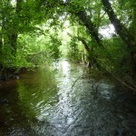
Adapting concepts and methods developed for areas of more intensive land use to blanket bog catchments in Ireland can prove challenging. A pilot study initiated when “Quantification of blanket bog ecosystem services to water” research began in Summer 2016 aimed to test concepts in a baseline study of a peat-covered catchment in south Co. Antrim that supply drinking water to the towns of Ballymena and Larne. The study area is underlain by basalt bedrock, overlain by variable thicknesses of glacial till and/or blanket bog peat. In areas lacking blanket bog, a covering of peat soil up to 50cm thick overlies till. Land use mapping across the area is dominated by forestry and open moorland, largely used for grazing.
Spatial mapping of water quality in three of the principal streams feeding a treatment plant provided a means of assessing both hydrological pathways delivering water to streams and the impact of contrasting land uses. Field water quality parameters that can be measured accurately and frequently, notably Specific Electrical Conductance (SEC), coupled with laboratory measurements of colour and pH provided inexpensive indicators of gross water quality. Surveys of the three streams carried out at three different times aimed to assess the consistency in readings.
The box and whisker plot in Figure 1 summarises the results of colour analyses for the three streams surveyed. The plot shows significant differences in water colour between sampling events, with variations within streams for each sampling event proving greater than between individual streams; the results of Specific Electrical Conductance measurements reveal a similar differences. Overall, data suggested that higher concentrations of colour occurred following periods of heavy rainfall, while this also resulted in lower Specific Electrical Conductance. However, spatial analysis of colour content reveals inconsistent trends with land use, with contrasts in water quality from streams flowing through afforested and grazed areas both varying by up to an order of magnitude. Figure 2 provides a representative indication of the variation spatial variation in colour levels in one of the catchments. Subsequent measurements showed these levels to rise by a factor of 4-5.
Study findings call some of the prevailing concepts underpinning blanket bogs hydrological models into question. Given the low pollution pressures observed in the area, coupled with typically low Specific Electrical Conductance levels in groundwater sampled from bog peat, elevated conductivity levels observed in stream water samples point to significant contributions of more mineralised groundwater. This in turn suggests that some bog water flows through peat to depth before discharging to streams. A review of peatland hydrological literature suggests that this issue has been largely overlooked.
In a related vein, water samples collected from streams flowing through afforested areas sometimes failed to show elevated Natural Organic Matter levels. This contrasts with findings from longer term studies but may be explained by the timing of the survey (summer 2016), during which time afforested areas can display elevated soil moisture deficits, attributable in part to the high levels of interception.
The results of this pilot study highlight the highly variable nature of stream water quality in peat-covered catchments in both space and time, and the requirement for more detailed studies spanning the hydrological year. This needs to be accompanied by integrated hydrological monitoring to better constrain competing conceptual models. This work will be completed by “Quantification of blanket bog ecosystem services to water” researchers over the next two years at a number of sites across Ireland. Findings along the way will be reported to the Catchments Newsletter.
Raymond Flynn, Sorcha Cahill and Katie Woodhouse, School of the Natural and Built Environment, Queen’s University Belfast
If you would like to know more about Quantification of blanket bog ecosystem services to water or peatland hydrological research in Ireland, please contact Dr Raymond Flynn at r.flynn@qub.ac.uk