The Environmental Sensitivity Mapping (ESM) Webtool is a novel GIS…
Environmental sensitivity mapping: supporting assessments and planning decisions in Ireland
The Strategic Environmental Assessment (SEA) Directive requires the assessment of potential environmental impacts resulting from the implementation of plans (e.g. river basin management plans, county development plans) and programmes (e.g. for waste management). The overall goal of SEA is to support sustainable development by incorporating environmental considerations into decision-making.
This is commonly done by determining the vulnerability or sensitivity of the areas likely to be affected by the plan/programme. Informed by this, recommendations are made to avoid or mitigate any potential significant environmental effects. Environmental sensitivity describes the susceptibility of natural resources (e.g. habitats, water bodies) to human-induced changes such as landuse modifications that may cause their degradation. Analysing a region’s characteristics that make it susceptible to change provides a valuable starting-point in plan-making, helping to direct developments to the most appropriate location.
The growing availability of spatial data and technological developments are resulting in a greater uptake of online GISbased decision support tools in planning and decision-making. Building on these advancements, a team of researchers led by UCD School of Geography, in collaboration with the All-island Research Observatory (AIRO) at Maynooth University, have developed an Environmental Sensitivity Mapping (ESM) web-tool to support SEA and planning decisions in Ireland.

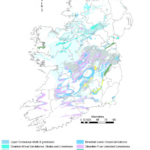
on the left menu, and bedrock aquifer map showing detailed attribute information
through a pop-up query window.
The ESM web-tool centralises access to well over 100 environmental datasets grouped by SEA themes, including water, allowing planners to rapidly and efficiently examine environmental considerations within their plan area. It also includes a bespoke and innovative analytical widget that enables creating plan-specific environmental sensitivity maps, without the need for specific GIS skills or expertise. Users can select a range of datasets from each SEA theme to include in the analysis (Figure 1), as relevant to the plan/programme under assessment. These datasets can be weighted to determine their relative importance and, in this way, capture stakeholder concerns/opinion (for example, on the importance of protecting nutrient sensitive water bodies), facilitating public consultation requirements in SEA. The final output provides an environmental sensitivity index map for the selected area (Figure 2) – which can help anticipate potential landuse conflicts to inform planning decisions.

The ESM web-tool is a publicly available, robust and innovative solution that can lead to more effective environmental assessments and, in turn, better plan-making in Ireland. It has already informed the National Planning Framework and the Regional Spatial and Economic Strategies, as well as various other applications at local level.
Ainhoa González
Learn more:
For more information on the web-tool, project background and
informative video on GIS and SEA, visit www.enviromap.ie – see
Start Mapping to access the web-tool.
Acknowledgements: The ESM web-tool is a collaborative public
sector data project between UCD School of Geography (concept and
design) and AIRO (analytics and mapping). The research was funded
and supported by the Environmental Protection Agency and the
web-tool is hosted by the Ordnance Survey Ireland on their GeoHive,
the State Geospatial DataHub.