Currently the EPA is evaluating the sources of pollution or…
“What exactly is the situation?” – Investigative Assessments can provide the answer
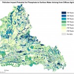
So ……we know that a rural stream is polluted (e.g. Ecological Quality value = 3-4; mean phosphate concentrations = 0.05 and therefore above the Environmental Quality Standard of 0.035 mg/l); we know that the only potential sources are farming (diffuse and farmyards) and septic tanks systems; the Source Load Apportionment Model indicates that ‘diffuse’ sources are a major pressure; the Pollution Impact Potential map indicates significant areas of Very High and High Pollution Impact Potential in the catchment area; but we don’t know the precise pressure type and location in order to decide on mitigation measures to improve the water quality. What do we need to do?
The answer may be simple in theory, but can be difficult in practice – we walk the stream, putting on our detective’s hat, and look for clues using a variety of techniques from different relevant disciplines. We can then pin down the issue(s) of concern, and conclude on what might be done about it. It might be asked, if the answer is that simple, has it not been done before? Well, it has, but resources have not always been available to do all that was needed, using all possible techniques. Also, the background information needed – on the physical setting, hydrochemistry, land-use, etc. – was not readily available until recently with the development of the EPA Water Framework Application.
The Starting Point – Water Framework Directive Characterisation
The WFD characterisation process being undertaken by the EPA in collaboration with local authorities involves three tiers of assessment:
- Preliminary water body risk screening.
- Initial subcatchment and catchment characterisation.
- Further characterisation.
The first two tiers are desk-based using:
- a broad range of ecological, hydrochemical and hydrogeological maps and data;
- information on pressures, e.g. Urban Waste Water Treatment Plants, farming, septic tank systems, forestry;
- results from load apportionment modelling;
- pollution impact potential maps; and
- results of previous investigative monitoring and inspections undertaken by local authorities.
Preliminary risk screening is undertaken nationally and identifies the water bodies that are At Risk or Not at Risk, based mainly on the available monitoring data, including assessments of status, trends and distance to threshold.
The initial characterisation process then confirms this identification, and focuses on water bodies that are At Risk (i.e. those requiring additional mitigation measures to be undertaken) and provides conclusions on the main issues, the significant pressures, and the proposed environmental objectives and associated measures.
However, while large point sources, such as waste water discharges, can be located and assessed readily, it is frequently not possible to locate and evaluate the significant pressures impinging on water quality in rural areas at this stage of characterisation. In these instances, further characterisation is necessary; without this, rectifying water quality problems is not feasible. This is where Investigative Assessments fit into the process of managing our water resources effectively.
Further Characterisation: The Investigative Assessment Approach
There are two overriding principles:
- Investigative Assessments follow the Source (or pressure)-Pathway-Receptor (S-P-R) model for environmental management. (These are easy words to write down,
but visualising each component, and the connections between them in a 3D landscape, is essential). - The level of investigation is proportional to the risk posed.
Three levels of assessment are proposed:
- Desk study, based on existing information, such as in the WFD Application, Google Earth and websites such as www.gsi.ie, www.opw. ie and http://gis.epa.ie/Envision.
- Field-based assessment, mainly by local authority staff.
- Specialist input, such as from hydrogeologists, agricultural scientists and biologists.
In this brief article, I will concentrate on the field- based assessment in At Risk stream catchments, although a desk-based assessment should always be undertaken prior to a catchment walk. As a hydrogeologist, I admit that I inevitably ‘see’ this work through ‘groundwater/geologist’ eyes, so make allowances! But, wearing my detective’s
hat as well, I start by asking myself what field techniques from the various relevant disciplines – e.g., hydrogeology, hydrology, agricultural science, hydromorphology, engineering, biology, hydrochemistry, social science – would be relevant.
Based on my own limited experience and input from colleagues in the Catchments Unit, the following information can be readily collected as part of a stream Investigative Assessment:
- Information and views of farmers and other householders.
- Location and description of potential point pollution sources, such as farmyards, septic tank systems, rural industries.
- Information on land-use, as a means of assessing potential ‘diffuse’ or non-point pressures.
- Clear buffer zones, riparian areas and, in the case of arable land, uncultivated setback areas alongside streams.
- Presence/absence of fences and hedges alongside streams.
- Indicators of water movement, such as drains/ditches, drainage density, poaching by farm animals, slope, evidence of land drains, and vegetation indicators such as rushes.
- Rock outcrops and relevant details derived from soil/subsoil exposures.
- Observation of hydromorphological issues, including new land reclamation, drainage, silting and stream channel maintenance.
- Field measurements of water conductivity, temp, Dissolved Oxygen and pH (acidity/ alkalinity) – see article page 22.
- Small Stream Risk Score assessments.
- Soil sampling and testing results, with nutrient management planning evaluation.
- Physico-chemical and chemical sampling, and subsequent analyses.
- Tracing to check connections with potential pollution sources and receptors (e.g., with dye).
- Taking soil samples by hand augering and trial pitting, as relevant, as a means of checking the soil and subsoil characteristics, and depth to bedrock.
This information can then be used to tell the ‘story’ of the stream in sufficient detail to enable a 3D understanding of water and contaminant movement and attenuation in the site/area, followed by ideas and proposals to mitigate the pressures on the stream.
On the face of it, this all seems obvious and simple. But, in my view, it isn’t! Few people, including myself, have the broad range of expertise and experience to undertake all the above adequately as an integrated and holistic process.
For instance, I don’t have sufficient basic biological knowledge, and I am conscious in writing this that there are biological indicators not mentioned above because I don’t know
what they are precisely, but that with some brief training a non-specialist like myself could use.
Investigative Assessments – The Future
The Catchments Unit, in consultation with the Environment Section of Tipperary County Council, has developed draft guidance on Investigative Assessments. In addition, we have produced an Excel spreadsheet to enable local authorities to estimate the staff resources needed to undertake Investigative Assessments in their county. For instance, the estimated resources that would be needed by Tipperary County Council to undertake Investigative Assessments is three person- years. This guidance is a ‘work in progress’, and is unlikely to be completed until early 2017.
In recent days, the EPA’s Ecological Monitoring & Assessment Unit has provided practical guidance for sampling lakes. Guidance on Investigative Assessments for towns/urban areas and high status water bodies are being developed; Investigative Assessment guidance for the zones of contribution of impacted wells and springs will be developed in the coming months, as will some techniques for assessing biological indicators. We also need to produce practical guidance on assessing the pathways for water and potential associated contaminants on land close to streams and ditches, particularly in poorly draining areas, and on the role of ditches themselves. However, guidance on its own won’t be enough – the resources to undertake Investigative Assessments will be essential.
In conclusion, we need to be able to tell ‘what exactly the situation is’ – general statements on the problems are inadequate. Where the answer isn’t known, Investigative Assessments are needed to provide it.
If you would like a copy of the current draft of the Guidance and/or would like to contribute views and information, please email catchments@epa.ie