Imagine you are out for a walk along the river…
The Story of the Suir
The June 2016 issue of the Catchments Newsletter had several articles telling The Story of the Suir. You can find all of them below, along with additional articles from the Local Authorities Waters and Communities Office who have been working with local communities along the Suir.
The Suir catchment is 3500 km2 in size, rising on the Devil’s Bit Mountain and flowing out to the sea at Waterford Harbour. It supports a population of approximately 200,000 spread across several urban centres and the rural population. The catchment supports a wide range of livelihoods and ecosystem services, but how are the catchment’s aquatic ecosystems coping with all these activities? Do we have the balance right between living and working in, and maintaining a healthy Suir catchment, and if not, what do we need to do to redress the situation?
This question is central to the Water Framework Directive river basin management planning process. Plans are made every 6 years containing actions to enhance and protect water quality and the ecosystems that depend on it. We are currently in the characterisation stage of the 2nd planning cycle which is due to culminate in our 2nd cycle plans being completed at the end of 2017, and implemented between 2018 and 2021. Characterisation of water bodies is a critical element of the work required under the Water Framework Directive, and is about understanding how our catchments work and how human activities impact on water, in order to prioritise appropriate actions that ensure that we do get that balance right.
In this 2nd cycle our philosophy is about looking for ‘the right measure in the right place’ to achieve the best outcome, which will build on the ‘one size fits all’ approach of the last cycle.
What does the River Suir mean to you?
Great turnouts and lively discussions were the order of the day for the recent River Suir community meetings. Over two weeks in July, evening meetings were held at six riverside locations throughout the River Suir catchment, specifically to ask local people “What does the River Suir mean to you?”.
The main purpose of the evening meetings was to open out the discussion on the Suir into water quality and other natural water issues, and explore opportunities that the Suir and its tributaries can provide to local communities.
Full article by Alan Walsh, Local Authorities Waters and Communities Office, is available at https://www.catchments.ie/river-suir-mean/
The River Suir has a Green and Blue Future
Those who live near the Suir have immediate access to a wonderful resource and there are many who regularly access the river for lifestyle and recreational purposes. Tipperary County Council engaged with these communities through two INTERREG co-funded projects, each of which had a focus on waterways. One of these projects was Green and Blue Futures: The social economy and the management of green infrastructure. This project looked at ways to combine social objectives, such as tackling unemployment and engaging disconnected youth, with environmental activities like protecting riverbanks, controlling invasive species and the productive use of green urban spaces. Social enterprise models were explored which combine a focus on positive social outcomes with a business model to generate income in order to move away from a reliance on grant funding.
Full article by Alan Walsh, Local Authorities Waters and Communities Office, is available at https://www.catchments.ie/river-suir-green-blue-future/
How healthy is the Suir Catchment?
In general aquatic ecosystem health in the Suir catchment is fairly good. The majority of surface water bodies were “Not at Risk” i.e. are expected to meet their Water Framework Directive objectives, meaning that no further actions are required in addition to the basic requirements of the current regulations and best practice management. Water quality trends are also generally improving across the catchment although there are some key hotspot areas where problems continue to arise. 64 (35%) surface water bodies, including the Suir estuary and 4 small groundwater bodies, were found to be At Risk and will require specific measures to achieve improved water quality outcomes. The vast majority of the water bodies containing the protected areas had also already met their objectives. The most significant water quality issue is excess phosphorus (P) from a variety of sources including human and animal wastes and fertilisers, leading to eutrophication, which is impacting on rivers, lakes and estuaries. The next step is to use the range of tools now available to us, which are described on this page, to help pin down exactly where and what the issues are in the problem areas we have highlighted and identify precisely what needs to be done to resolve them.
A collaborative, focussed effort will be needed to tackle the significant pressures identified in the Suir catchment. It will need to involve multiple agencies, including staff from the new Waters and Communities office, and the local landholders. Such a collaborative approach will be essential to achieve that balance that will sustain a productive, yet healthy, Suir catchment for the long term.
Full article by Jenny Deakin, EPA Catchments Unit, is available at https://www.catchments.ie/healthy-suir-catchment/
The Suir Estuary = the canary for its catchment?
As the ultimate receptors of all the inputs upstream, the estuarine and coastal areas can tell us a lot about what is happening in the overall catchment. We can use the biological communities to tell us about nutrients in the water, or chemical pollutants. Useful indicators to look at nutrient pressures are the seaweeds.
We use the presence and abundance of certain seaweeds, such as sea lettuce, to tell us about the nutrient conditions in the estuary. In areas where nitrogen inputs increase these green seaweeds can grow in huge quantities causing an environmental impact. Other indicators of nutrient pressures are the phytoplankton communities (small plants that grow suspended in the water column) which can change depending on the balance of nutrients coming downstream. In severe cases this can result in large harmful algal blooms that can affect the other marine communities, such as shellfish or the bottom dwelling animals. In the Suir we have seen some disturbances to the marine plants with elevated levels of phytoplankton in the water suggesting that the nutrient conditions are too high. We can use this information, along with the other data from our monitoring programmes, to work out what has to be done to improve the situation. By looking at the estuary and coastal areas we can develop an idea of the sort of changes that need to take place in the whole catchment for improvement across all our waters.
Full article by Robert Wilkes and Sorcha ni Longphuirt, EPA is available at https://www.catchments.ie/suir-estuary-catchment/
Measuring how the Suir flows, from the mountain to the sea
River levels and river flows are measured on the Suir and its tributaries by the Environmental Protection Agency (EPA) in conjunction with the Local Authorities for:
- drinking water supply resource assessment,
- waste water discharge assimilative capacity1 calculations,
- environmental monitoring,
- conservation, and
- to enable planning and development proposals to be assessed.
The Office of Public Works also measures river levels and river flows in the catchment for drainage and flood management purposes. The hydrometric gauging station networks in the catchment are complimentary, with data shared between organisations to avoid duplication of effort. All Hydrometic Data is available at www.epa.ie/hydronet
Full article by Conor Quinlan, EPA is available at https://www.catchments.ie/measuring-suir-flows-mountains-sea/
What’s living in the Suir?
The various uses of rivers can involve conflicting interests and often such uses disrupt the ecology or health of the river. The fact that several of the more important beneficial uses of rivers such as drinking water abstraction, amenity uses like water sports, and waste water disposal are all dependent on biological processes is rarely appreciated.
Biological monitoring of Irish rivers and streams was first undertaken in the 1970’s and since then has continued on a three year survey cycle.. A total of 215 river sites are surveyed in the Suir catchment alone including 138 biological and 139 chemistry sites. Under the biological programme, the macroinvertebrate fauna (small animals without a backbone that can be seen with the naked eye) and the aquatic plants and algae residing in the river are examined, the species are identified, and their relative abundances are recorded. Using their known sensitivities and tolerances to pollution, biological indices can be applied to the observed data to summarise their ecological condition classifying the river site from satisfactory, that is High or Good condition, to unsatisfactory: Moderate, Poor or Bad conditions.
Full article by Catherine Bradley, EPA is available at https://www.catchments.ie/whats-living-suir-healthy-rivers/
How chemical monitoring of our rivers can help us understand their story – why, what, where and when.
Water does not exist in its pure form in the natural environment, it is truly reflective of its surroundings, influenced by where it originates, what it flows over and percolates through. Under natural conditions the chemical characteristics of our water bodies originate from a variety of sources, including leaching of soils, weathering of minerals and atmospheric inputs. These chemicals, in both dissolved and particulate forms, reach the water body via a number of pathways, and in the case of surface water have resulted in a natural background level of chemical constituents in which aquatic biota have developed.
Water quality monitoring is fundamental in the management of water resources that support healthy and productive aquatic ecosystems as well as sustainable and healthy water supplies and chemistry monitoring is an integral part of any water monitoring programme.. Monitoring for identified chemical compounds highlights any significant changes or trends that may be evident in water bodies over a period of time.
Full article by Kieran Gordon, EPA is available at https://www.catchments.ie/chemical-monitoring-rivers-can-help-us-understand-story/
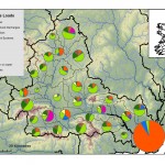
What’s flowing into the Suir? Results from nutrient load apportionment modelling
Where rivers and lakes are impacted by excess nutrients, we need to understand the sources of those nutrients before mitigation measures can be selected. In these areas, modelling can be used in conjunction with knowledge from local authorities and investigative assessments to identify significant pressures that contribute excessive nutrients to surface waters. In the Suir catchment, only a relatively small proportion of the catchment requires a reduction in phosphorus emissions to achieve Good Status.
Modelling future scenarios can support catchment scientists and managers in identifying appropriate options for measures. Just as pie making isn’t an exact science, modelling the sources of river nutrients can have errors and unknowns. Nonetheless, we can use these results to help support decision making and the integrated catchment management process and, ultimately, to improve our ecosystems and environment. Further information on the EPA CatchmentTools Project can be found at cwrr.ucd.ie/cmst
Full article by Eva Mockler, UCD Research Fellow, is available at https://www.catchments.ie/whats-flowing-suir-results-nutrient-load-apportionment-modelling/
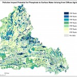
Water Quality and Agriculture: Pollution Impact Potential Maps – A tool to guide resources into areas for further investigation
As the philosophy being followed to improve our water quality where needed is “the right measure in the right place”, investigative assessments are being recommended as the means of locating the significant pressures (see next article), including from diffuse sources. To help reduce the amount of investigative assessments required and therefore the time and resources needed, a Catchment Characterisation Tool has been developed to produce Pollution Impact Potential (PIP) maps that show the potential critical source areas for agricultural diffuse nutrients in our water bodies and subcatchments. The Pollution Impact Potential maps rank the relative risk areas for diffuse phosphorus to surface water and diffuse nitrogen to surface and groundwater. These maps are now available to all public bodies on the WFD Application.
Full article by Marie Archbold, EPA, is available at https://www.catchments.ie/water-quality-agriculture-pollution-impact-potential-maps-tool-guide-resources-areas-investigation/
“What exactly is the situation?” – Investigative Assessments can provide the answer
After all our scientific monitoring and assessment is completed, we may still not know the precise pressure type and location in order to decide on mitigation measures to improve the water quality. What do we need to do?
The answer may be simple in theory, but can be difficult in practice – we walk the stream, putting on our detective’s hat, and look for clues using a variety of techniques from different relevant disciplines. We can then pin down the issue(s) of concern, and conclude on what might be done about it. It might be asked, if the answer is that simple, has it not been done before? Well, it has, but resources have not always been available to do all that was needed, using all possible techniques. Also, the background information needed – on the physical setting, hydrochemistry, land-use, etc. – was not readily available until recently with the development of the EPA Water Framework Application.
There are two overriding principles:
- Investigative Assessments follow the Source (or pressure)-Pathway-Receptor (S-P-R) model for environmental management. (These are easy words to write down, but visualising each component, and the connections between them in a 3D landscape, is essential).
- The level of investigation is proportional to the risk posed.
Three levels of assessment are proposed:
- Desk study, based on existing information, such as in the WFD Application, Google Earth and websites such as www.gsi.ie, www.opw.ie and http://gis.epa.ie/Envision.
- Field-based assessment, mainly by local authority staff.
- Specialist input, such as from hydrogeologists, agricultural scientists and biologists.
Full article by Donal Daly, EPA Catchments Unit, is available at https://www.catchments.ie/exactly-situation-investigative-assessments-can-provide-answer/