
National River Macroinvertebrate Surveys Data in Ireland
The Environmental Protection Agency (EPA) in Ireland is responsible for the ecological monitoring and assessment of over 13,000 km of river channel nationwide. Our national macroinvertebrate dataset, collected for WFD purposes from 2007 onwards is now available for download.
Why monitor rivers?
Ireland is as much blue as green. Our island has over 84,000 km of river channels and more than 12,000 lakes. Rivers act like the land’s capillaries and blood vessels, carrying water from mountains to the sea. Because rivers and streams are closely linked to surrounding land, they are vulnerable to pollution from human activities. Monitoring helps protect drinking water, wildlife habitats, and the benefits rivers provide for food, tourism, and recreation.
Ireland’s River Monitoring Programme
The Environmental Protection Agency (EPA) monitors over 13,000 km of river channels nationwide. Ireland has one of Europe’s oldest river monitoring programmes, starting in 1971 and focusing primarily on benthic macroinvertebrates (i.e. larval insects (e.g. mayflies, stoneflies, caddisflies, beetles, etc.) together with crustaceans (e.g. shrimps), snails and bivalves, worms, and leeches).
Since the EU Water Framework Directive (WFD) in 2000, monitoring has focused on ensuring all our waterbodies (rivers, lakes, groundwater sources, estuaries and coastal waters) remain healthy and restoring those that are polluted. EPA ecologists assess more than 2,800 river stations at least once every three years.
Our most recent results are available on the EPA Geoportal (Water Quality and Monitoring tab)
What are macroinvertebrates and why they matter
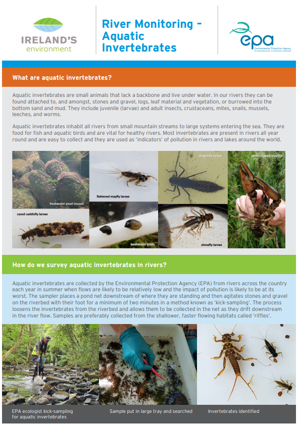
Macroinvertebrates are small animals without backbones that live on riverbeds, such as:
- Insect larvae (mayflies, stoneflies, caddisflies, beetles)
- Crustaceans (shrimps)
- Snails and bivalves
- Worms and leeches
These species are excellent indicators of water quality because they respond to pollution over time, showing long-term changes in river health.
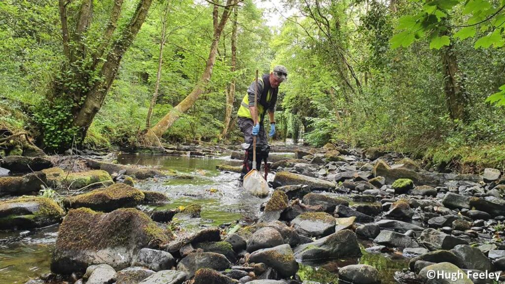
How surveys are carried out
The majority of data is collected using a standard 2-minute kick sample with benthic macroinvertebrates identified and roughly counted on the bankside before being returned to the river. This biological monitoring is combined with chemical tests for a full picture of water quality.
What the data tells us
These surveys provide a spatial and temporal dataset that reveals how pollution affects rivers and tracks trends over time. The data shows strong links between macroinvertebrate communities and:
- Land use: urbanisation and agricultural intensity
- Catchment pressures: human and livestock densities
- Chemical indicators: phosphorus, ammonia, nitrogen, oxygen demand, pH, and conductivity
This information is vital for assessing ecological status under the WFD and planning measures in River Basin Management Plans.
More background information can be found in our paper published in Scientific Data in 2020: A national macroinvertebrate dataset collected for the biomonitoring of Ireland’s river network, 2007–2018 | Scientific Data
Learn more
Ireland’s National Water Framework Directive Monitoring Programme, 2022-2027
The EPA runs a national monitoring programme to check water quality under the WFD. It covers rivers, lakes, coastal waters, and groundwater using long-term checks and targeted surveys where problems are likely. This data tracks progress toward environmental goals and informs River Basin Management Plans.
River Monitoring – Aquatic Invertebrates
This fact sheet explains how the EPA monitors river water quality using aquatic invertebrates as indicators of pollution. It outlines why they are important and describes the kick sampling method used to collect and assess them under the Water Framework Directive.
Who is involved?
Quite simply, everyone in Ireland has a role to play. This can be from something as simple as making sure you don’t pollute your local stream, or a local community working together to establish a Rivers Trust to enhance the rivers and lakes in their area, to a Government Department or Agency helping a Minister implement a new policy to help protect and enhance all our water bodies.
This website has been developed and is maintained by the Environmental Protection Agency, and is a collaboration between the Department of Housing, Planning and Local Government, the Environmental Protection Agency, and the Local Authority Waters Programme.
Local Authority Waters Programme
The Local Authority Waters Programme coordinates the efforts of local authorities and other public bodies in the implementation of the River Basin Management Plan, and supports local community and stakeholder involvement in managing our natural waters, for everyone’s benefit.

Environmental Protection Agency
The EPA is responsible for coordinating the monitoring, assessment and reporting on the status of our 4,842 water bodies, looking at trends and changes, determining which waterbodies are at risk and what could be causing this, and drafting environmental objectives for each.

Department of Housing, Local Government and Heritage
The Department is responsible for making sure that the right policies, regulations and resources are in place to implement the Water Framework Directive, and developing a River Basin Management Plan and Programme of Measures to protect and restore our waters.