Rivers trusts are charities, established by local people to look…
National River Macroinvertebrate Surveys in Ireland, 2007-2018
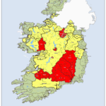
The Environmental Protection Agency (EPA) in Ireland is responsible for the ecological monitoring and assessment of over 13,000 km of river channel nationwide. Our recent national macroinvertebrate dataset, collected for WFD purposes and just published in Scientific Data, covers the period 2007 to 2018 and has over 10,000 unique data records.
Ireland is as much blue as it is green. Our small island has well over 84,000 km of river channel and more than 12,000 lakes. The river network, in many ways, acts like the capillaries and blood vessels of the land, flowing from the high mountains to the hill to the plains and onwards eventually reaching the sea. The intricate connection between land and water means that our streams and rivers are highly susceptible to what happens on the adjacent land area. Therefore, there is a need to monitor and assess these water bodies to ensure that on-going human activities do not pollute or degrade the very waters we use daily for our drinking water, but also provide us with food, amenities, tourism and habitats for nature.
Ireland has one of the oldest river ecological monitoring programs in Europe, having started in 1971 and focusing primarily on benthic macroinvertebrates (i.e. larval insects (e.g. mayflies, stoneflies, caddisflies, beetles, etc.) together with crustaceans (e.g. shrimps), snails and bivalves, worms, and leeches). Since the introduction of the EU Water Framework Directive (WFD) in 2000, the EPA’s work and legislative support has become more focused and now aims to ensure all our rivers (as well as our lakes, groundwater sources, estuaries and coastal waters) remain unpolluted and those that are polluted are returned to unpolluted conditions. Consequently, EPA ecologists visit and assess more than 13,200 km of river channel (or over 2,800 individual river stations) throughout the country, at least once every three years. Our most recent results are available here.

Our recent national macroinvertebrate dataset, collected for WFD purposes and just published in Scientific Data (https://doi.org/10.1038/s41597-020-00618-8), covers the period 2007 to 2018 and has over 10,000 unique data records.
The majority of data were collected using a standard 2 minutes kick sample with benthic macroinvertebrates identified and roughly counted bank-side.
These surveys have been vital in indicating the changes that pollution brings about in our river network and provides a valuable spatial and temporal dataset that highlights the changes and trends in Irish river systems, with significant relationships between the macroinvertebrate community present and measures of urbanization and agricultural intensity, densities of humans and cattle within a catchment, but also chemical indicators of water quality, namely molybdate-reactive phosphorus, ammonia, total oxidized nitrogen, biological oxygen demand, pH and conductivity.
In more recent years the dataset has been used by others in a variety of ways including, for example, river biodiversity assessments, species atlases, and International Union for Conservation of Nature (IUCN) red listing. We envisage that this dataset will be useful to a wide range of users in the future. Our purpose here is to widen the knowledge of, and accessibility of, these data.
Hugh Feeley, Scientific Officer, Environmental Protection Agency
Learn more:
doi.org/10.1038/s41597-020-00618-8