Phosphorus is an essential nutrient for crop production, but is…
Dingle Hub, Kerry – real-time remote sensing to allow continuous water quality monitoring
Can networked real-time remote sensors and other new technologies enhance existing measures to protect our water catchments while helping to improve the efficiency of farming? Deirdre de Bhailís tell us how Dingle Hub are working with the local community to see what is possible…
With the global population set to exceed 9 billion by 2050, there is now an urgent need to significantly increase food production. However, against the backdrop of climate change this must be done in a sustainable and environmentally-friendly manner. The Dingle Creativity and Innovation Hub (Dingle Hub) aims, through a series of test and trial projects, to show that digitisation using real-time, remote monitoring techniques of current water sampling processes and of the farming industry will be an important part of the solution.
The Dingle Hub is a not-for-profit organisation that provides infrastructure and works to foster the ecosystem necessary to generate enterprise and support the increase in high-skilled employment on the Dingle Peninsula. Dingle Hub manages a number of community benefit projects in three key areas of local strength:
- Marine and the Environment;
- Internet of Things (IoT);
- Music, Film and Animation.
When tourism constitutes a key player in a coastal economy, there are uncertain and often competing interactions between environmental and socioeconomic processes. Management plans to date have emphasized development rather than the interaction of tourism and environmental systems. While recent research has demonstrated that the tourism carrying capacity (TCC) concept is applicable to tourist destinations in coastal areas, most of these studies primarily focused on either economic or environmental factors in natural areas, not a combination of both.
Researchers at Sacred Heart University (SHU) are working to help advance the integration of ecological and social sciences within the study of coastal tourism by developing comprehensive models, and building an international network for interdisciplinary research. The methods and results will be applicable to coastal tourist towns around the globe. Water quality monitoring networks are essential to characterize and manage water quality accurately, and are important in water basin decision making.
The installation of on-line instrumentation to provide continuous water quality measurement has many advantages. Where discrete sampling provides a snap shot of nutrient concentration and water quality at any given time, the provision of continuous water quality measurement provides a detailed picture of events, minute by minute. This data allows scientists and engineers to identify in real-time, a failing parameter affecting water quality. Continuous water quality monitoring systems allow nearly instantaneous notification of poor water quality events as they occur, allowing for immediate corrective action to be taken.
To support this work, Dingle Hub, in collaboration with Sacred Heart University, applied to Bord Iascaigh Mhara (BIM) Fisheries Local Action Group (FLAG) South West, and were awarded European Maritime and Fisheries Fund (EMFF) funding under the Fisheries Local Area Development Scheme through BIM to progress with an Internet of Things (IoT) Water monitoring project. Additional support for nitrate sensors in the Milltown and Owenmore Rivers was provided by the LA Waters Programme. The aim of this test and trial project is to showcase the potential of IoT technologies to help stimulate enterprise in this area. The output will be an automated monitoring system for conductivity, dissolved oxygen, pH, water temperature, nitrates, and water levels. This system will identify changes in, and provide a record of, the above environmental parameters.
The project is currently deploying and integrating water sensor nodes with IoT gateway technologies to provide real-time data in a cost-efficient manner. Using a bespoke dashboard, a cloud-based storage platform will capture the data, store the data, and make the data available in accordance with agreed protocols.
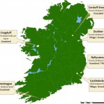
in the Milltown River during a period in August 2018, while Figure 2b shows the conductivity for the same period. The areas for the additional nodes are Dingle Bay, Ventry Harbour, Tralee Bay, Milltown River, Owenmore River, Maine River and Castlemaine Harbour. This technology, when fully built, will pave the way for advance warning systems and can be reproduced inexpensively for deployment in other localities.
The follow-on project proposal to use IoT Technologies to develop a system to support farmers in complying with complex environmental regulations, and assist with increasing the overall efficiency of farming, was the key focus of a workshop hosted by Dingle Hub on 16 July 2016. Figure 3 shows a graphic of the main building blocks required for an IoT network to provide Smart Agriculture solutions. The water monitoring network contains all the same components, but simply with different sensor options.
Participants from the local farming community, the Environmental Protection Agency, Teagasc, Inland Fisheries, Kerry County Council, Net Feasa, Sacred Heart University, Institute of Technology, Tralee, Dublin City University, University College Cork, Transition Kerry, North East West Kerry Development and many more brought their significant expertise to help enhance the project proposal. It was very encouraging to have so much interest in this project, and an important opportunity to bring together so many key people and organisations to enable the co-creation of technology solutions.
Deirdre de Bhailís, Dingle Creativity and Innovation Hub
Learn more:
Dingle Creativity and Innovation Hub: Live in a Creative Place, Work in a Creative Space