A clean-up of the River Barrow and Duiske River took…
Measuring the impact of the 2018 summer drought on river flows and lake levels
The drought of summer 2018 was a unique opportunity to measure how much water was flowing when levels were approaching the lowest recorded flow seen in decades. Conor Quinlan tells us how the EPA captured as many low flow measurements as possible, which will be vital for updating our long-term flow statistics.
Ireland experienced its first widespread drought in many years during the summer of 2018. Following a wet winter and spring, from May onward rainfall levels were much lower than long-term averages. By mid-July river flows across most of the country were approaching annual low levels usually observed around August- September. With Met Éireann forecasting no significant break in the dry weather, it became apparent that river flows could potentially fall to levels not seen since the mid-1970s.
Irish Water had highlighted the risk posed to water supplies by the drought, and the National Emergency Coordination Group met weekly to manage the situation. This triggered an intensified low flow measurement programme by the EPA Hydrometric and Groundwater Section, together with the Hydrometric Section of the OPW, and consultants on behalf of Irish Water, to ensure that the impact of the dry weather on river flows across the country was accurately and comprehensively measured throughout the drought.
This work measured flows at priority monitoring sites identified in the National Hydrometric Monitoring Programme 2018-2021, and at sites identified through recent WFD characterisation work as rivers that were potentially At Risk due to abstraction pressures.

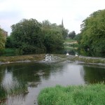
The Shannon, downstream of Lough Allen, Summer 2018 – it’s not often you can walk across the Shannon here.
The National Hydrometric Working Group coordinates the activities of organisations involved in this area. Working relationships developed through this forum made it possible to coordinate both a programme of flow measurement throughout the summer drought, and to produce weekly maps and summaries of the actual state of river flows and lake levels to inform the work of the National Emergency Coordination Group.
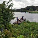
Low flow measurement, particularly in large rivers, is physically demanding work. When flows fall to low levels in rivers such as the Nore, Barrow, Munster Blackwater, or the Owenduff in Mayo for example, the river may either flow very shallowly in the river bed, or may split into two or more sub-streams with wide stretches of gravel or cobbles in between.
Accurate measurement of the flows in such channels requires reshaping the river bed using hand tools to guide the flow into a channel with low enough turbulence and sufficient depth of water to measure using a current meter. In cases where a river flow is too wide and shallow, the river may have to be “banked in” from its original width to a measurable channel of less than half that width by creating a stone and silt or mud embankment either side of the channel. Weed growth must also be removed from upstream and downstream of the flow measurement site to provide stable and low turbulence measurement conditions. This work usually takes 1 to 2 hours at each site and in some instances the temporary banks must then be dismantled following the measurement so no obstructions to flow are left in the river which could result in increased silt build up.

The Upper Liffey, upstream of Poulaphouca, July 2018 – only 5 metres wide.
River flows were so low this summer that the Rivers Nore and Barrow could be measured in small channels only four meters wide, while the Liffey and even the River Shannon could safely be waded across.
The nine field-based staff of the EPA hydrometric team, assisted by three usually office-based colleagues, took 439 flow measurements between June and September 2018, with the highest weekly total of 90 during the height of drought conditions in July.
The information obtained will be vital to updating our long-term flow statistics which facilitates accurate licencing of discharges, and in the future, abstractions, WFD characterisation, and the real-time management of water supplies.
While average river flows can be accurately modelled, it is much more difficult to model low flows successfully as small localised variations in groundwater storage and discharge can greatly affect the low flow behaviour of a river. Indeed, from early July onward, all water remaining in Irish rivers had either emanated from lake storage or from groundwater aquifers, as all surface runoff had long since made its way into the ground, lakes, or to the sea.
Due to such uncertainties in low flow estimation, regular physical measurements of low flows are required to maintain the accurate calibration of national river flow models. Changing precipitation patterns due to climate change are also predicted to result in differing regional responses in terms of summer low flows. Regionally representative low flow measurements are needed to accurately measure whether and to what extent such changes are occurring, and to identify emerging trends in a timely fashion. This information will be crucially important in enabling us to sustainably plan for and manage our water supply and waste water infrastructure, and to protect our aquatic environment into an uncertain future.
The coordinated national response in hydrometric data collection during the 2018 drought provides a good example of how services can be effectively delivered by a group of organisations working together within the framework of established working groups and national plans. Work is now ongoing within the EPA using the data collected during the drought to re-analyse our existing low flow statistics and hydrometric station calibrations.
Although flows did not generally fall to the low levels observed in the mid-1970s, for many stations, particularly those operational for less than 20 years, new record lows were recorded during 2018. The incorporation of this data into our existing record and models will enable us to identify catchments where WFD characterisation information may require upward or downward revision. Our analysis of results from rivers potentially at risk from abstraction or changing trends due to climate change will also inform the development of the national hydrometric network in the next planning cycle, from 2022 to 2027.
Conor Quinlan, EPA Hydrometrics and Groundwater Section
Learn more:
http://www.epa.ie/hydronet/#Water%20Levels